Wat Tham Patihan
Photo from TiewPaiKinPai.com
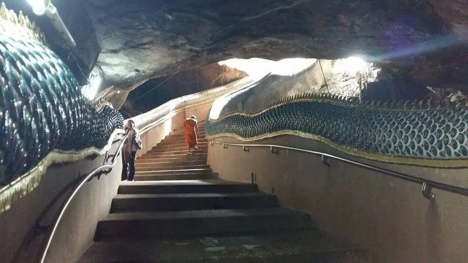
Wat Tham Patihan is another tourist attraction in Khong Chiam District. According to legend, Wat Tham Patihan is a hidden realm (Muang Lap Lae or Muang Bang Bot). According to the history of Luang Pu Kham Khaning Chulamani of Wat Tham Khuha Sawan, Luang Pu mentioned this dark cave as a connecting passage between the human realm and the underworld (the realm of the Nagas), a sacred land guarded and protected by a grandfather spirit (Chao Pu). It is also believed that this cave can be walked through to the other side at Si Phan Don rapids in Laos. The atmosphere inside the cave features a Naga staircase extending down into the cave. The air inside the cave remains cool at all times, and during the rainy season, water drips down from the cave walls. Once past the Naga staircase, you will find a large hall enshrining Buddha images in various postures for visitors to worship for good fortune. In the past, inside this cave there was a large log (about 3 people hugging around) well known to local elders. However, nowadays, since this cave was discovered and visited by many people, that log has disappeared from the cave on its own... Outside the cave area, Buddha images are enshrined at various points throughout the temple grounds, surrounded by nature with wild orchids growing all across the temple grounds. Almost forgot to mention, this dark cave temple comes before Pha Chana Dai, serving as a passage up to Pha Chana Dai. Tham Muet or Tham Patihan is located within Pha Taem National Park, Na Pho Klang Subdistrict, Khong Chiam District.
Pattaya Noi

Photo from Pantip.com
Pattaya Noi Beach, also sometimes called the Sea of Southern Isan, is located at Ban Mai Phu Thong, Khan Rai Subdistrict, Sirindhorn District, Ubon Ratchathani Province, along the edge of the Sirindhorn Dam reservoir. From Warin Chamrap, follow Highway 217 (Sathitnimankan Road) for about 62 kilometers, with another access point 2 kilometers away (kilometer markers 62 and 64, respectively), or about 10 kilometers from Sirindhorn Dam. The terrain along the reservoir is a wide sandy ground stretching out into the water, so people have opened restaurants, resorts, and cafes on floating rafts in the water. During the dry season when the water level above Sirindhorn Dam drops significantly, white sandy beaches appear where visitors can swim. With efforts to develop it into a water tourism destination, vendors provide boats, jet skis, and swim rings, turning Pattaya Noi into a recreational destination fully equipped with convenient facilities for tourists in every aspect.
Kaeng Saphue
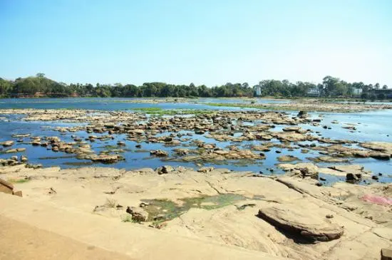
Photo from Tripadvisor
Kaeng Saphue is a rocky cataract similar to "Sam Phan Bok." During the flood season, the rocky rapids are submerged under water and eroded by swirling water currents into numerous small hollows and basins. When the water in the Mun River dries down in the dry season, these rocks emerge above the water, turning into a natural wonder in the middle of the Mun River. It offers an opportunity for tourists to admire the beauty of rocks eroded into artistic curves resembling circles, ovals, stars, and many other shapes, as far as the imagination goes. This atmosphere can only be experienced from February to May. During the rainy season, although the beautiful rock formations cannot be seen, it is a fun time for swimming because the current flows at just the right strength, with the water level neither too shallow nor too deep. In addition, the rocks are heavily covered with moss and algae, making them soft and slippery so you can enjoy swimming without worrying about sharp edges. Beyond being a popular tourist spot for the people of Ubon Ratchathani, every year during the Songkran festival, this location is also used to host the Kaeng Saphue Songkran Traditional Festival to promote tourism and preserve cherished traditions.
Hat Salueng
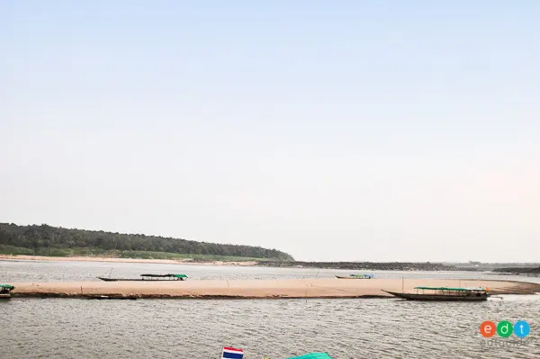
Photo from EDTguide.com
Had Salueng is one of the famous attractions in Pho Sai District. Had Salueng is located at Ban Song Khon, Song Khon Subdistrict, Pho Sai District, approximately 115 kilometers from the provincial center along Highway 2050 (Ubon - Trakan Phuet Phon - Pho Sai). The highlight of Had Salueng is during the dry season or Songkran, when Songkran celebrations take place here. Many young people come to play in the water, and as the Mekong River recedes, a white beach of fine sand is revealed. It is also a viewpoint where you can photograph Laos. Tractor-pulled cart services are available for those who want an easy ride up and down the beach. Had Salueng also offers many accommodations and restaurants, and you can easily travel on to Sam Phan Bok, as Ban Song Khon is roughly halfway between Pho Sai and Sam Phan Bok. Since Sam Phan Bok has limited lodging options, it is recommended to book accommodations here as a backup. In addition, there are restaurants and souvenir shops available. When it comes to beaches in Pho Sai District, Had Salueng at Ban Pak Kalang, Song Khon Subdistrict is the most beautiful beach, and you can also continue on to many other destinations, such as Sam Phan Bok, Sao Chaliang, Pha Chan, and Khong Chiam, as well as return to the city via this route. Therefore, starting your exploration of Pho Sai District begins by arriving at Ban Song Khon first.
Thung Na Mueang Waterfall
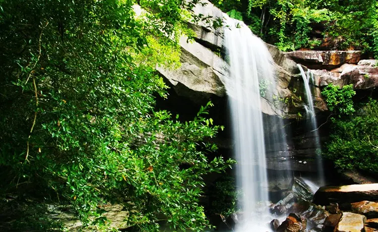
Photo from Woody Food Travel: relaxed eating and traveling Woody's style
Thung Na Mueang Waterfall is another waterfall located within Pha Taem National Park that flows only during the rainy season. It is situated just about 2 km from “Saeng Chan Waterfall (Namtok Ru, Namtok Long Ru, Namtok Lod Ru).” Sometimes local villagers also refer to “Thung Na Mueang Waterfall” as “Namtok Lod Ru,” causing some confusion with “Saeng Chan Waterfall.” The reason “Thung Na Mueang Waterfall” is also known as “Namtok Lod Ru” is that the stream flows along a creek into rock crevices, winding through hidden passages until it re-emerges beneath a massive rock slab situated like a cave gorge, cascading down as a waterfall in front beneath that rock slab.
Two-Colored River
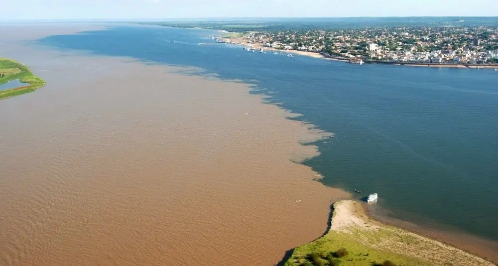
Photo from Travel MThai
The Two-Colored River is another must-visit attraction in Ubon Ratchathani Province. It is a natural phenomenon where two rivers converge, creating a striking contrast between the colors of the two waterways: the Mun River flowing into the Mekong River. Especially during the rainy season and high-water season, you can distinctly see the two converging rivers in two different colors on opposite sides. People call it “Khong Si Pun, Mun Si Khram” (the reddish-brown Mekong, the indigo Mun). In addition to witnessing the wonder of the two-colored river, you can also take a boat trip along the Mun and Mekong rivers to admire the natural scenery and observe the local way of life along both riverbanks. The two-colored river phenomenon, “Khong Si Pun, Mun Si Khram,” where the rivers merge into two colors, occurs around Don Dan at the mouth of the Mun River, Ban Woen Buek, Khong Chiam Subdistrict, Khong Chiam District, Ubon Ratchathani Province. Here, the indigo Mun River flows into the murky, reddish-brown Mekong River, creating a two-colored river before gradually blending into a single uniform color. Spots where you can view the two-colored river include the sloping riverbank in front of Wat Khong Chiam and at Huai Mak Village. You can reach them by boat by parking at the Mekong River Pier in Khong Chiam District and taking a boat to view the beauty of the two-colored river from both vantage points. Besides viewing the two-colored river, there are other attractions in the area, such as restaurants serving fresh fish caught from the Mun and Mekong rivers, or crossing over to explore the market in neighboring Lao People's Democratic Republic, visiting the morning market in Khong Chiam District, Pak Mun Dam, Heo Sin Chai Waterfall and Cave, Wat Tham Khuha Sawan, and the riverside fish landing.
Khua Noi Ban Chi Thuan
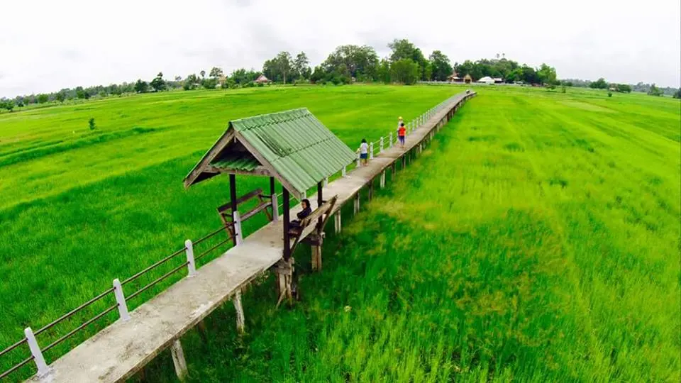
Photo from Phatchara View Resort Ubon Ratchathani
Khua Noi, Ban Chi Thuan, Chi Thuan Subdistrict, Khueang Nai District, Ubon Ratchathani Province is a footbridge used for travel between Moo 1 Ban Chi Thuan and Moo 7 Ban Nong Khaen. Based on inquiries with local community elders, it is estimated to date back about 200 years. It is 1.40 meters wide, 271.50 meters long, and approximately 1.50 meters high.
Had Sai Sung
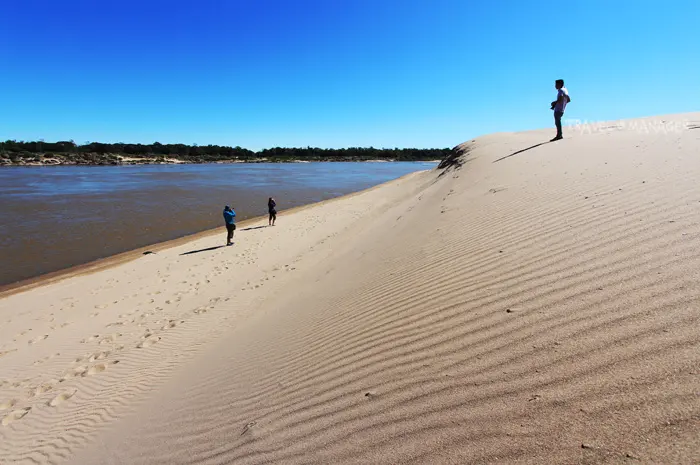
Photo from Thailand Tourism Directory
Had Sai Sung was formed by the Mekong River washing sand from other areas and depositing it over a long period alongside the river course. The sand dunes resemble two adjacent mounds; further down, there is a scenic pool of water flowing against rocks. Experience homestay tourism at Ban Lat Charoen, Moo 10, Na Waeng Subdistrict, Khemarat District, Ubon Ratchathani Province. History of the village: The first group of ancestors who settled the village in earlier times were Mr. Kam Laonoi, Mr. Chu Manthanarak, and Mr. Kanha Inthisaeng. It was originally named Ban Lat Noi, falling under the administrative jurisdiction of Moo 5 Ban Lat Ya Kha, Na Waeng Subdistrict, Khemarat District, Ubon Ratchathani Province. Later, on May 13, 1993, it was separated into its own administrative unit as Moo 10 and named “Ban Lat Charoen,” Na Waeng Subdistrict, Khemarat District, Ubon Ratchathani Province. The first village headman was Mr. Buppha Inthisaeng, and the current village headman is Mr. Champa Thongsopha. Ban Lat Charoen has a population of 420 people across 108 households, covering an area of 1,560 rai. It is located to the east of Na Waeng Subdistrict and Khemarat District. To the north and east, it borders the banks of the Mekong River along the border of Songkhone District, Savannakhet Province, Lao PDR. Transportation and access: It is approximately 25 kilometers from Khemarat District along Strategic Road No. 2112 (Khemarat - Khong Chiam route) and about 128 kilometers from downtown Ubon Ratchathani.
Giant Sao Chaliang
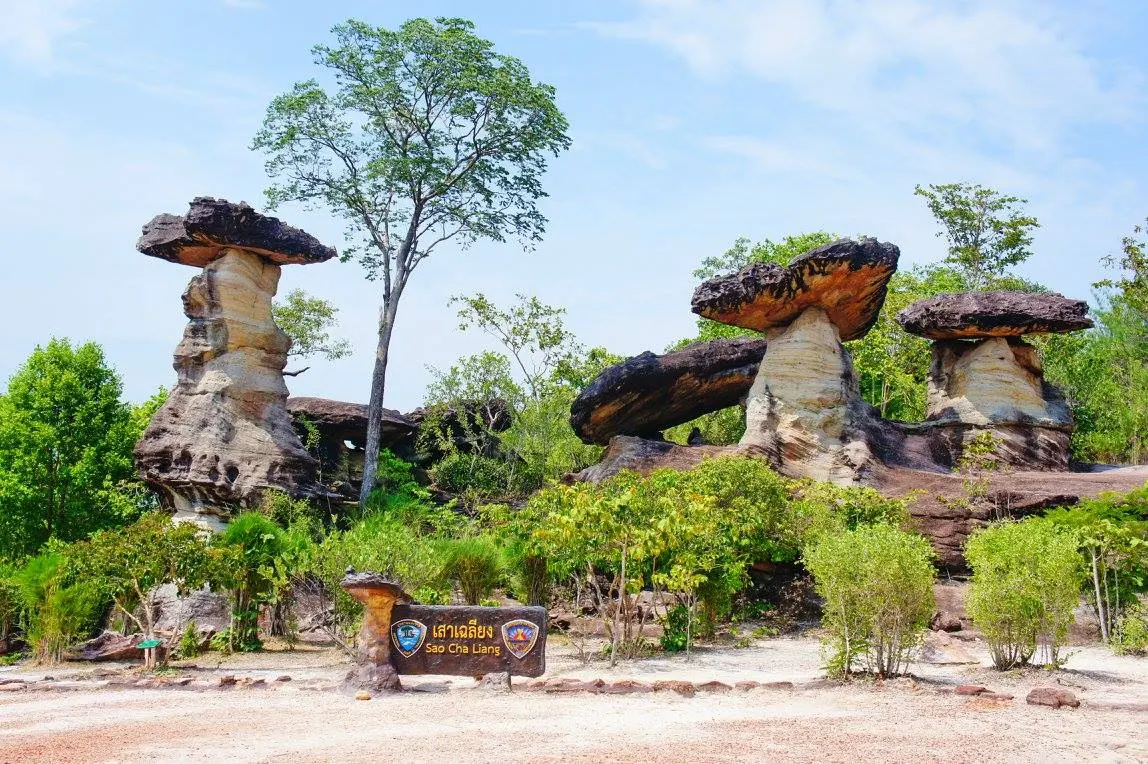
Photo from Museum Thailand
Giant Sao Chaliang is located in Pha Taem National Park, about 50 kilometers from the park headquarters, in the area of Ban Pha Khan, Pho Sai District, Ubon Ratchathani Province. Site highlights: Among the several Sao Chaliang geomorphological sites in Ubon Ratchathani Province, Giant Sao Chaliang is the largest Sao Chaliang in Thailand. It is about 20 meters high and about 10 meters wide. The surrounding area is an open rocky hill surrounded by mixed deciduous forest with many rare and unusual plant species. In addition, at the base of Giant Sao Chaliang on the western side, there are archaeological traces, including an ancient wooden coffin about 2 meters long, which is believed to belong to ancient humans 6. Geology: A mushroom-like natural sculpture formed by in situ weathering and erosion of hard and soft rock layers of the Phu Phan Formation, about 110 million years old. Because the rock layers have differing resistance to these processes, they erode unevenly; the softer rock layer erodes more, leaving a shape resembling the stem of a mushroom, while the harder rock layer erodes less, leaving a shape resembling the cap of a mushroom.
Planning it yourself?
What independent travellers usually book before they go, from providers that actually work

Thai language, pay in baht
 Photo: Nopparat thanatawan · CC BY-SA 4.0 · Wikimedia Commons
Compare many rental companies on one page

Popular with Thai travellers, Thai-language pages
 Photo: Christophe95 · CC BY-SA 4.0 · Wikimedia Commons
Hotels near the station and old town, many with free cancellation
Partner links · we may earn a small commission when you book, your price stays the same
Let Rin design a trip for your group