Pha Sok, Khong Chiam
This is another place with a story.
Getting here is not hard at all. It is like any trek: if you know the starting point (the trailhead) and the final destination, it is not complicated. The problem was that I did not know the starting point, and at the same time the information from Google about the final destination was very wrong.
You can come here on your own. Just do a little homework. There are two ways to reach it: from Soi Sawan Waterfall, starting from the village nearby, or via Tham Kaew Nopparat Monastery in Tha Lang village (at the foot of Pha Taem, where you can drive right up, which is very convenient).
I chose to go up via the monastery. The problem was where to start climbing without scaling a steep cliff, because looking toward the cliff I could hardly see any path up.
I parked and walked to the temple. I could not find anyone around, but I happened to meet the abbot, so I asked him which way to go. He said to go behind the temple and then follow the path on the right. I asked whether it was hard to walk, and he said there is a path all the way. Look for the water pipes the villagers have laid, and if you get lost, hold on to the line of rocks along the watercourse. Reaching Pha Sok should take no more than 45 minutes.
Now I had the information, so I started. I followed what he said and turned right onto a small path through a cassava field. It began to get steep until I reached a rocky clearing. I noticed a path cutting across the field toward the cliff. I checked the location of Pha Sok on the GPS, and yes, this was definitely the way. Past the rocky clearing I saw a small trail and kept walking until I found a watercourse with a blue PVC pipe laid down along it. Yes, that was it! I followed the pipe and climbed over rocks for a long while. It was very tiring. At one point there was an arrow drawn on a rock to show the direction, and in some places there were snack wrappers on the path, so I was definitely on the right track. After walking a while, oh, the pipe ended here and there was no more of it. All I could tell was that, looking along the cliff, I could start to see the cliff at the Pha Sok point the GPS had shown. But how to climb up? The path ran along the watercourse with big boulders that I had to cross back and forth. I started to feel unsure. After walking for an hour and a half, this was definitely not right. I had come so far, so why couldn't I get up the cliff?
I decided to walk back. Oh no, I got lost, because I had cut through the forest along a tiny gap trying to find a way up the cliff. What to do? I had to find the watercourse somehow. I pushed through a bamboo forest full of thorns, going round and round for almost half an hour, until I found the watercourse. I jumped and climbed down along the rocks, hoping to find the PVC pipe, but I never did. Never mind, I just kept going down. There was very little water left, so I had to hurry, and it was incredibly hot.
Judging from the direction on the GPS, it did not lead to the temple at all. I stopped cutting through the bamboo forest because it was brutal. I figured that if I just kept going down, I would eventually reach the Mekong.
Wow, it was extreme. I came across the villagers' cassava field. Without waiting, I walked across the field to find the villagers. There were bags for collecting cassava, so there should be people around here, and there really were. I asked for directions until I finally got back to the temple. It was a huge detour, 5555.
Before reaching the temple I met a villager harvesting cassava and asked the young man how to get to Pha Sok. He said to go to the small house before the temple, then turn left, and there would be a path.
What? The abbot had said to go right. In the end the penny dropped: the abbot was right, but his right was not mine (we were talking face to face). In short, I wasted 3 hours lost in the forest, and my arms were covered in scratches.
Back at the car, I checked what was left in my backpack: three roasted cassava roots and 500 cc of water. Okay, time to test my luck. I would follow the young man's directions one more time.
Walking up to Pha Sok is not hard at all, it is very easy. Park following the map in the picture below. Take the path on the left toward the small house. Do not walk to the temple. Keep going, pass the house and go around behind it. There is a clear path, and most importantly there is a water pipe, just as the abbot said, but this one is an iron pipe, 5555.
Follow the path along the water pipe for a while until you reach a large square cement water tank. You will see the pipe connecting to the tank and running in a long line along the path. Just keep walking, it is very easy. The pipe must stay on your right at all times. You might walk so far that you can no longer see the pipe, especially on the uphill stretch, but the pipe will always be on the right side. The path starts to get steep as you climb the hill. In some sections the trail is very ambiguous, especially where you have to cross small rocky clearings. Look for markers made of piles of stones or tree branches. (Even with markers, I still got lost in some spots on the way down. If you get lost, do not carry on; go back and start again each time.)
The path goes up and up all the way. If the path starts to go downhill at any point, it is wrong, so go back quickly and start again.
I followed the path for 22 minutes from the small house and saw a line of iron pipe again. Just walk across the pipe. After crossing for a short while, you reach a very wide, flat rocky clearing. By this point the walking is no longer tiring, but where next? There is no trail. I walked straight ahead a little and found two rock pillars as in the picture. According to the GPS, the pond is on the right, so if you find these pillars, you have come the right way.
Look carefully beside the pillars on the right-hand side and you will see a path running along the cliff face. Follow this path up to the next level of rock, then keep walking along the cliff edge. It takes about 25 minutes to reach the pond (timed on the way back).
If you go the wrong way, return to the pillars and look for the path again. Do not cut inland. I cut across and found a track like a vehicle road, and I followed it without knowing where it went, further and further away from the cliff. I guessed it led toward Soi Sawan Waterfall because of the direction, so I had to walk all the way back, which was a real waste of time. I had only 300 cc of water left, but it should be enough.
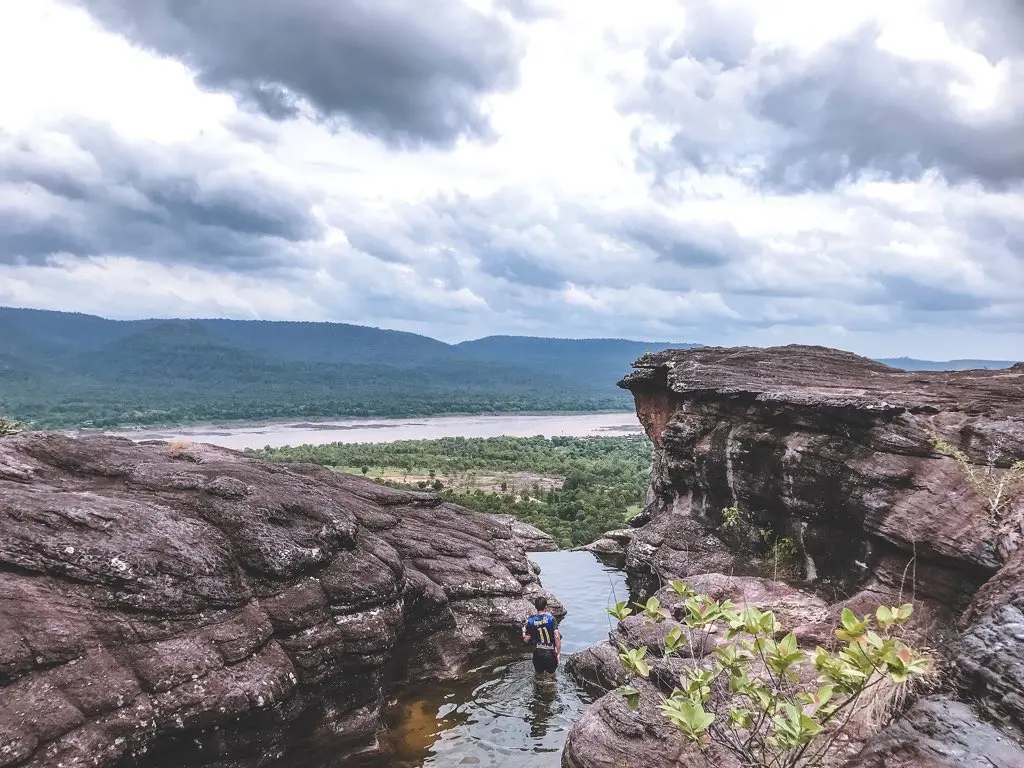
I walked to the GPS point, but let me tell you, it is completely wrong. If you want to go, mark this new point, which I marked myself by hand: 15.418252,105.570883. And do not walk toward the tall cliff, because it is on a different rock level. Just follow the cliff edge and you will find it.
When I arrived, I was the only one there. I wanted to strip off and jump into the water because it was so hot, but the water was stagnant. I scooped some up to smell it and it stank terribly, so I decided not to get in. I sat eating roasted cassava and enjoying the Mekong view, very content, though it was really hot. As for my plan to visit the rocking stone at Phu Samui, I probably will not go now, since my legs are about to cramp.
Planning it yourself?
What independent travellers usually book before they go, from providers that actually work

Thai language, pay in baht
 Photo: Nopparat thanatawan · CC BY-SA 4.0 · Wikimedia Commons
Compare many rental companies on one page
Popular with Thai travellers, Thai-language pages
Museum and landmark tickets, ready on your phone
 Photo: Christophe95 · CC BY-SA 4.0 · Wikimedia Commons
Hotels near the station and old town, many with free cancellation
 Photo: Ddalbiez · CC BY 3.0 · Wikimedia Commons
City tours with transport and guide, book ahead
Partner links · we may earn a small commission when you book, your price stays the same
Let Rin design a trip for your group